Spiders photographed on Mars?

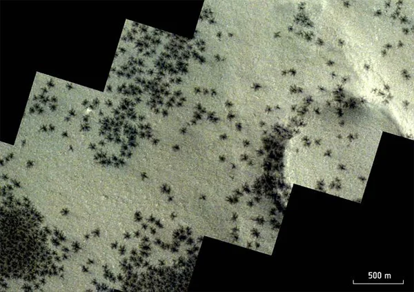
In fact, these formations are not actually spiders that have been photographed on Mars. The small, dark shapes emerge when spring sunlight hits layers of carbon dioxide deposited during the dark months of the Martian winter. Under solar influence, the carbon dioxide ice at the base of these layers turns to gas, accumulating and breaking up the upper ice sheets.
During the Martian spring, the released gas, loaded with dark particles, drags dark material with it as it moves, fracturing layers of ice up to a meter thick. This gaseous emanation, loaded with dust, erupts through cracks in the ice in the form of tall columns or geysers, before rushing back to the surface, depositing there. This process results in the formation of dark spots with diameters ranging from 45 meters to 1 kilometer.
Furthermore, this same process carves distinctive “spider” patterns beneath the ice, suggesting the possible presence of arachnids. Recently, new images captured by the European Space Agency’s (ESA) ExoMars TGO and Mars Express spacecraft offer a clear look at the tentacle-like patterns of these supposed spiders.

The spider web-like channels captured by TGO are located close to but outside the area visible in the new Mars Express image, where the dark spots stand out on the surface due to the release of gas and material.
These dark patches can be discerned throughout the Mars Express image, encompassing majestic hills and vast plateaus. However, most of them are concentrated in the shadowy region on the left, located on the outskirts of a portion of Mars nicknamed “Inca City”. The origin of this epithet is not enigmatic, since the linear and practically geometric arrangement of the elevations evokes Inca ruins. Formally known as Angustus Labyrinthus, the Inca City was identified in 1972 by NASA’s Mariner 9 probe.
Planetary scientists continue to explore the mysteries surrounding the formation of the “Inca City.” To date, there is no consensus on its origin. One possibility is that the sand dunes have undergone a process of petrification over time. Another theory suggests that materials such as magma or sand may be seeping through fissures in Martian rocks. It is also hypothesized that the ridges could be “ eskers ”, sinuous formations associated with glacial activity. The debate remains open as experts continue their investigations.

The “walls” of the Inca City delineate a significant portion of a broad circle, spanning some 86 kilometers in diameter. As a result, scientists hypothesize that this “city” is located inside a vast crater, created by the impact of a celestial body on the Martian surface.
This impact probably induced the formation of fissures in the adjacent plain, which were filled over time by volcanic activity and gradually faded away. Towards the core of the image, the landscape takes on a subtle transformation, with large oval swirls giving it a marble-like appearance. This phenomenon is attributed to the erosion over time of the stratified deposits present in the region.

In the central right area of the image, prominent mountains and hills stand out, characterized by steep slopes and flat ridges that rise more than 1,500 meters above the surrounding terrain. These formations arise from the gradual erosion of softer materials over time, whether due to the action of wind, water or ice, leaving behind the resistant materials that make up these elevations.
In the adjacent region to the right (north), the ground becomes progressively covered with a layer of soft, light dust. Here and there, signs of spider-like formations are noticeable, scattered across the plateaus, among various canyons and depressions, as if they were lurking.


